Reclaimed Land Intelligence

Prove the ground beneath your assets.

TerraWatch measures ground motion for reclaimed land and coastal megaprojects using satellite radar and a supervised AI pipeline. Millimeter scale precision, more than a decade of retroactive history, and zero sensors on site. Every result passes strict quality gates and carries an expert signature.

11.4 yearsverified radar archive depth over our Gulf demo districts
5,800+ scenesindexed across six districts in Dubai and Abu Dhabi
638 productsprocessed in the first interferometric campaign

The measurement gap

Ground risk is priced on assumption.

01

Fill settles for years

Reclaimed ground consolidates long after placement. Building too early risks structural damage; building too late burns financing cost. The timing question is worth millions, and it is answered by guesswork.

02

Sensors cannot see backwards

Levelling, GNSS and extensometers measure single points, from installation day onward only. The decade of ground behavior before your survey simply does not exist for them.

03

Institutions carry the exposure

Insurers underwrite it, banks lend against it, buyers acquire it. Billions in asset value sit on ground whose behavior nobody measures independently.

Product

One platform across the life of the land.

Ground behavior does not begin at handover and it does not end at completion. TerraWatch covers the full lifecycle, from the acquisition decision to decades of operation.

Phase 0

Site Intelligence Report

Before land is acquired or a project breaks ground: 10 to 30 years of retroactive ground behavior for the parcel and its surroundings, risk zoning, and guidance that sharpens foundation design and borehole campaigns.

Before acquisition
Phase 1

Consolidation Monitoring

While fill settles and construction proceeds: settlement rates on every satellite pass, consolidation curves, readiness forecasts, and monitoring of neighboring structures during excavation.

During construction
Phase 2

Continuous Assurance

Through the operating life of the asset: per building velocity and risk scores, automatic alerts on trend breaks, portfolio dashboards, periodic signed reports, and an API for institutional workflows.

In operation

The platform

From radar archive to decision surface.

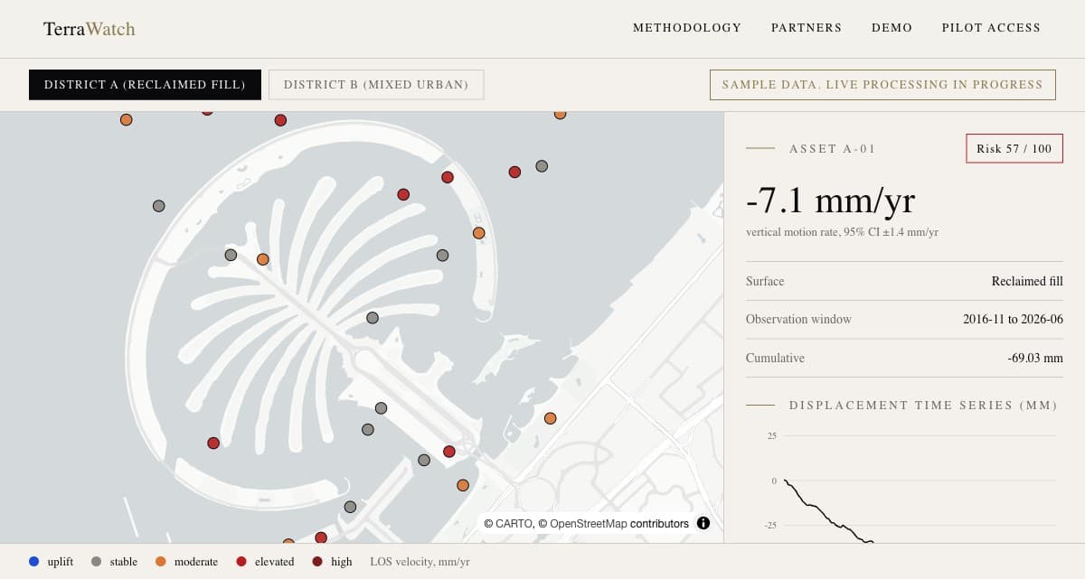
Color coded velocity across a district. Click any point for its full displacement history with confidence intervals. Trend break alerts, portfolio views, signed periodic reports, and an API for institutional workflows.

  • District velocity map, point by point
  • Per point time series with confidence intervals
  • Risk scores and trend break alerts
  • Underwriting API and signed PDF reports
Open the live demo

Public demo shows the interface with sample data. Live measurements are confidential and shared with pilot participants under NDA.

terrawatch — monitoring console
TerraWatch monitoring dashboard: district velocity map with per point time series

How it works

Five gates between raw radar and your desk.

Transparency builds trust. The full methodology, including our quality thresholds and the limits of the technique, is public. Read the methodology.

01

Archive

A decade of radar scenes over your district, already collected

02

Interferometry

Hundreds of scene pairs processed in the cloud

03

Time series

Millimeter scale motion history for millions of points

04

Quality gates

Coherence, plausibility and stability thresholds; below the bar, nothing ships

05

Expert signature

A geodesy PhD reviews and signs every client report

The archive advantage

The history already exists. We read it.

No instrument on earth can measure the past. Radar satellites have been imaging the Gulf continuously for over a decade; every parcel already has a measurement history. Verified over our demo districts:

0 yrsof continuous radar archive depth
0+scenes indexed across six districts
0interferograms processed in campaign one
0%of the workflow runs on supervised AI agents

Who it serves

Built for the people who need to know.

Findings are confidential and delivered only to the commissioning client. Public material uses anonymized, methodological examples only.

01

Insurers

Independent ground verification as an underwriting input. Price risk on measurement, not assumption.

02

Banks and lenders

Collateral risk visibility for assets on reclaimed and coastal ground, at origination and across the loan book.

03

Due diligence advisors

A decade of ground behavior on the table before the transaction closes. Delivered inside your deal timeline.

04

Government and infrastructure

District scale monitoring for municipalities, transport, and ports. Continuous, historical, and sensor free.

05

Developers and asset owners

A stability certificate backed by independent satellite measurement. Prove the quality of your ground to buyers, insurers, and lenders.
Findings go to one place: the client who commissioned them.

Confidentiality is not a policy footnote here; it is the architecture. Measurement data is access gated, reports travel under NDA, and public material never contains an identifiable finding.

Questions institutions ask

Asked and answered.

The satellite data is public. What do we pay for?

The archive is open; the intelligence is not. Gulf specific processing knowledge, per asset risk products, QC gates and an expert signature chain turn raw phase data into decisions you can defend.

Does this replace geotechnical investigation?

No, it sharpens it. Satellite measurement tells you where to look and where to drill; boreholes remain the ground truth. We partner with geotechnical firms in joint delivery.

Who sees our findings?

You, and only you. Findings are delivered under NDA to the commissioning client. Public material uses anonymized, methodological examples only, with no exceptions.

How do we know a result is reliable?

Every figure carries a confidence interval. Results that fail coherence, plausibility or reference stability thresholds never leave the pipeline, and a geodesy expert signs everything that does.

Pilot program

Request early access.

We are onboarding a limited number of design partners across insurance, banking, due diligence, government, and development. First historical analyses over Dubai and Abu Dhabi districts are processing now; pilot participants receive findings privately, under NDA. Commercial terms are finalized with management.